These are the complete worked solutions for the S6 Geography II NESA Advanced Level Examination, 2024–2025, sat on 15 July 2025. This paper applies to combinations HEG, MEG, MPG, BCG, LEG, and HGL.
Every question is rewritten in full and answered immediately with a clear explanation. Use this alongside the S6 Biology II 2025 worked solutions if you are in BCG, and the S6 Chemistry II 2025 worked solutions for your full combination coverage.
If any topic needs deeper revision, book a Geography tutor on Mathrone Academy for one-on-one past paper practice.
TO GO ALONG WITH ANSWERS DOWNLOAD THE QUESTION PAPER HERE
PART I: Physical Geography
Section A: Attempt ALL Questions (26 marks)
Question 1 (4 marks)
i) Which of the following is most closely associated with the movement along faults?
- A) Ocean currents
- B) Earthquakes
- C) Hurricanes
- D) Tornadoes
Answer: B) Earthquakes
A fault is a fracture or zone of fractures in the Earth's crust along which blocks of rock have moved relative to each other. When stress builds up along a fault and is suddenly released, the energy radiates as seismic waves causing an earthquake. The San Andreas Fault in California and the East African Rift System are well-known examples. Ocean currents are driven by wind and temperature differences. Hurricanes and tornadoes are atmospheric phenomena unrelated to fault movement.
ii) Which of the following landforms is created by the deposition of sediments by waves?
- A) Cliff
- B) Sea stack
- C) Beach
- D) Wave-cut platform
Answer: C) Beach
A beach is a depositional landform formed when waves lose energy and deposit the sediment (sand, gravel, shingle) they have been carrying. Beaches form in sheltered bays where wave energy is lower. Cliffs, sea stacks, and wave-cut platforms are all erosional landforms — they are created by waves wearing away rock, not depositing material.
Question 2 (4 marks)
i) How are sedimentary rocks formed?
- A) By the accumulation and cementation of sediments
- B) By the transformation of existing rocks through heat and pressure
- C) By the cooling and solidification of magma or lava
- D) By the growth of crystals from a solution
Answer: A) By the accumulation and cementation of sediments
Sedimentary rocks form through a multi-stage process: weathering and erosion break existing rocks into particles (sediments); these particles are transported by water, wind, or ice; they are deposited in layers; and over time, the weight of overlying layers compresses the sediment (compaction) while minerals precipitate between grains binding them together (cementation). Examples include sandstone, limestone, and shale. Option B describes metamorphic rock formation. Option C describes igneous rock formation.
ii) What type of rock forms from the cooling and solidification of molten magma?
- A) Sedimentary
- B) Metamorphic
- C) Organic
- D) Igneous
Answer: D) Igneous
Igneous rocks are formed directly from magma (molten rock beneath the surface) or lava (magma that reaches the surface). When magma cools slowly underground, it forms intrusive igneous rocks with large crystals (e.g. granite). When lava cools rapidly on the surface, it forms extrusive igneous rocks with small crystals (e.g. basalt). The name "igneous" comes from the Latin ignis, meaning fire.
Question 3 (4 marks)
i) What is the definition of climate?
- A) The weather conditions over a short period of time
- B) The long-term patterns of temperature and precipitation in an area
- C) The daily fluctuations in wind and temperature
- D) The air pressure in the atmosphere
Answer: B) The long-term patterns of temperature and precipitation in an area
Climate refers to the average atmospheric conditions particularly temperature, precipitation, humidity, wind, and sunshine — recorded over a long period (typically 30 years) in a particular region. Weather, by contrast, describes short-term atmospheric conditions at a specific time and place. A common saying is: "Climate is what you expect; weather is what you get." Options A and C describe weather, not climate. Option D describes only one atmospheric variable.
ii) Which of the following best describes a desert climate?
- A) High rainfall and warm temperatures
- B) Low rainfall and hot temperatures
- C) High humidity and cold temperatures
- D) Consistently cool temperatures
Answer: B) Low rainfall and hot temperatures
Desert climates (classified as BWh in the Köppen climate system for hot deserts) are defined by very low annual precipitation (typically less than 250 mm per year) and extreme heat. The Sahara Desert in Africa and the Arabian Desert experience very little rain and daytime temperatures regularly exceeding 40°C. Cold deserts (like the Gobi) exist too, but the defining characteristic of all deserts is aridity (low rainfall), not temperature alone.
Question 4 (4 marks)
i) The Earth's inner core is primarily composed of:
- A) Liquid iron and nickel
- B) Solid iron and nickel
- C) Solid rock and minerals
- D) Water and gases
Answer: B) Solid iron and nickel
Despite being the hottest part of the Earth (temperatures around 5,000–6,000°C), the inner core is solid rather than liquid. This is because the enormous pressure at the Earth's centre (over 3 million atmospheres) prevents the iron-nickel alloy from melting, even at these extreme temperatures. The outer core, by contrast, is liquid iron and nickel and its movement generates Earth's magnetic field through the geodynamo effect.
ii) Which of the following is the correct order of Earth's layers from outermost to innermost?
- A) Crust, Mantle, Outer Core, Inner Core
- B) Outer Core, Mantle, Inner Core, Crust
- C) Mantle, Crust, Outer Core, Inner Core
- D) Crust, Outer Core, Mantle, Inner Core
Answer: A) Crust, Mantle, Outer Core, Inner Core
From the outermost to the innermost layer: the Crust (thin outer shell, 5–70 km thick); the Mantle (semi-solid rock, approximately 2,900 km thick, making up most of Earth's volume); the Outer Core (liquid iron and nickel, about 2,200 km thick); and the Inner Core (solid iron and nickel, radius approximately 1,220 km). This structure was determined through the analysis of seismic wave behaviour during earthquakes.
Question 5 (2 marks)
What is the term for the process by which sediment is moved along the coast by wave action?
- A) Erosion
- B) Transportation
- C) Deposition
- D) Sedimentation
Answer: B) Transportation
Transportation is the process by which eroded material (sediment) is moved from one place to another by a transporting agent — in this case, waves. Along coasts, the most significant form of coastal sediment transportation is longshore drift: waves approach the beach at an angle, swash carries sediment up the beach at that angle, but the backwash flows straight back down the beach under gravity, so sediment gradually moves along the coastline in a zigzag pattern. Erosion refers to the wearing away of rock. Deposition is when transported material is dropped. Sedimentation describes the settling of particles.
Question 6 (4 marks)
i) Which of the following is a positive impact of volcanicity on humans?
- A) Destruction of settlements
- B) Fertile soil for agriculture
- C) Loss of life
- D) Air pollution
Answer: B) Fertile soil for agriculture
Volcanic eruptions deposit lava and ash that, over time, weather into extremely fertile soils rich in minerals such as potassium, phosphorus, and calcium. These soils support high agricultural productivity. This is why some of the world's most densely populated farming areas are found near volcanoes — the slopes of Mount Kilimanjaro in Tanzania and Mount Elgon on the Uganda-Kenya border are examples. Options A, C, and D are all negative (destructive) impacts of volcanic activity.
ii) What is the primary difference between intrusive and extrusive volcanic features?
- A) Intrusive features form above ground, while extrusive form below ground
- B) Extrusive features form above ground, while intrusive form below ground
- C) Intrusive features involve only lava, while extrusive involve gases
- D) There is no difference
Answer: B) Extrusive features form above ground, while intrusive form below ground
Intrusive (plutonic) volcanic features form when magma cools and solidifies below the Earth's surface before reaching it. Examples include batholiths, dykes, sills, and laccoliths. Because cooling is slow underground, crystals are large (e.g. granite). Extrusive (volcanic) features form when magma reaches the surface as lava and solidifies above ground. Examples include volcanoes, lava plateaus, and geysers. Rapid cooling at the surface produces fine-grained or glassy rocks (e.g. basalt, obsidian).
Question 7 (4 marks)
i) Why is natural vegetation important for the environment?
- A) It provides food and shelter for wildlife
- B) It helps regulate the climate and maintain biodiversity
- C) It supports human economic activities
- D) All of the above
Answer: D) All of the above
Natural vegetation provides multiple overlapping benefits. It provides food (fruits, nuts, leaves) and shelter (trees, undergrowth) for wildlife — supporting food chains and ecosystems. It regulates climate by absorbing CO₂, releasing oxygen, moderating temperatures through shade and transpiration, and influencing rainfall patterns. It maintains biodiversity by providing diverse habitat niches. It also supports human economic activities through timber, non-timber forest products, ecotourism, water regulation for agriculture, and medicinal plants. All three individual options are correct, making D the most complete answer.
ii) Which one is NOT a condition necessary for the growth of mountain vegetation?
- A) This type of vegetation requires the gentle gradient
- B) Well distributed rainfall characterised by humid conditions
- C) Fertile soils that are well-developed with moderately acidic soil pH
- D) Temperature ranges of about 20°C at 900 m and 4°C in the summit region
Answer: A) This type of vegetation requires the gentle gradient
Mountain vegetation (afromontane forests, montane grasslands, alpine vegetation) does not require gentle gradients — it grows on steep mountain slopes. In fact, steep gradients are characteristic of mountain environments. The other three options are genuine conditions for mountain vegetation: well-distributed rainfall and humid conditions (B) are correct — mountains receive orographic rainfall; fertile, moderately acidic soils (C) are typical of montane environments; and the temperature range given in (D) correctly describes the altitudinal temperature gradient, with cooler temperatures at higher elevations.
Section B: Attempt Only TWO Questions (14 marks)
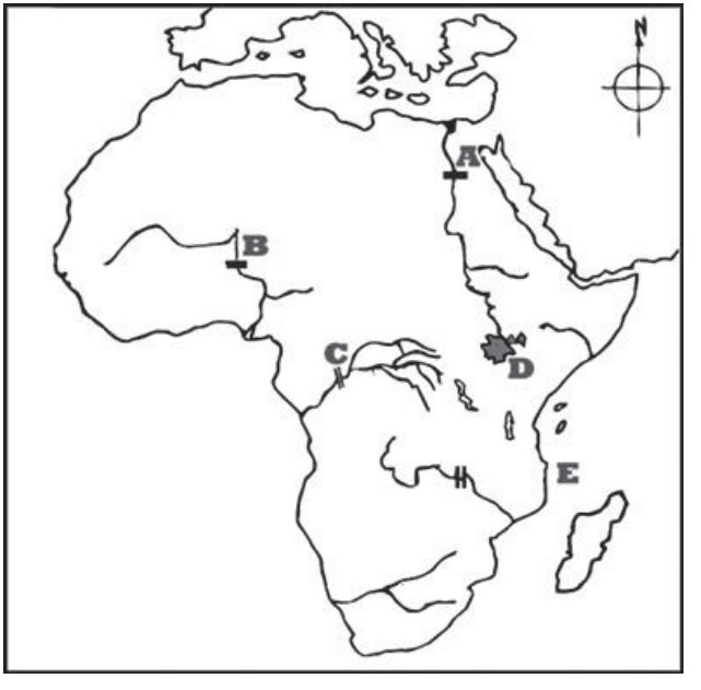
Question 8: HEP Map of Africa (5 marks)
The map of Africa shows hydroelectric power projects labelled A, B, C, D, and E.
Question 9: Soil Erosion (7 marks)
a) What is soil erosion? (1 mark)
Soil erosion is the process by which the top layer of soil (topsoil) is removed, loosened, or washed away from the land surface by natural agents such as water (rainfall and runoff), wind, or ice, or by human activities such as deforestation and poor farming practices.
b) Explain 3 measures taken by people in Rwanda to prevent soil erosion. (6 marks)
1. Terracing
On the steep hillslopes that characterize much of Rwanda's landscape, farmers construct terraces broad, level steps cut horizontally into the hillside. Terraces reduce the speed and volume of water running down slopes, giving rainwater time to infiltrate into the soil rather than rushing downhill and carrying soil with it. The Rwanda government has invested heavily in terracing as part of its land husbandry programme, and terraced hillsides are visible across the Western Province and other highland areas. Each terrace acts as a mini-flat field that holds soil and water, reducing erosion and improving crop yields simultaneously.
2. Agroforestry and Planting of Vegetation
Planting trees, grasses, and shrubs along field boundaries and on steep slopes stabilises soil through root systems that physically bind soil particles together. Tree roots penetrate deeply, anchoring soil even during heavy rain. The canopy of leaves breaks the force of raindrops before they hit the bare soil, reducing splash erosion. Rwanda's national tree-planting campaigns and policies requiring vegetation on steep slopes above 55% gradient (where cultivation is banned) are direct measures against soil erosion.
3. Contour Farming and Strip Cropping
Farmers in Rwanda plant crops along the natural contour lines of hillslopes rather than up and down the slope. When crops are planted across a slope (contour farming), the rows of plants act as natural barriers that slow water runoff and trap eroding soil. In strip cropping, alternating strips of different crops (e.g. sorghum and grass strips) are planted across the slope. The dense root systems and plant cover of alternating strips reduce water velocity and filter out sediment. These techniques are widely taught and practised in Rwanda's rural agricultural communities.
Question 10: Bar Graphs (7 marks)
a) Define a bar graph. (1 mark)
A bar graph is a statistical diagram that uses rectangular bars of equal width but varying heights (or lengths) to represent and compare data values for different categories or time periods. The height (or length) of each bar is proportional to the value it represents, allowing visual comparison between categories.
b) Describe any three advantages of a simple bar graph. (6 marks)
1. Easy to read and interpret
Bar graphs present data in a visual format that is immediately understandable even to readers with limited statistical knowledge. The differences in bar heights make comparisons between categories instantly apparent without requiring numerical calculation. For example, a bar graph showing Rwanda's coffee export volumes over five years allows a reader to identify the highest and lowest production years at a glance. This visual clarity makes bar graphs widely used in reports, presentations, and examinations.
2. Effective for comparing discrete categories
Bar graphs are particularly suited for showing differences between separate, distinct categories such as comparing population sizes of different countries, rainfall totals across different months, or the GDP of different African nations. Each bar stands alone, making the distinction between categories visually clear. Unlike line graphs (which imply continuity between points), bar graphs communicate that the categories are independent of each other, which accurately represents discrete data.
3. Simple to construct
A simple bar graph requires only basic tools: graph paper, a ruler, and the data values. The construction process is straightforward — draw axes, mark a uniform scale on the vertical axis, and draw bars to the correct height. This simplicity makes bar graphs accessible for students in schools across Rwanda, in field research, and in government reports. No specialist software or advanced mathematical knowledge is required to produce an accurate and informative bar graph.
Section C: Compulsory Question (10 marks)
Question 11: Topographic Map Analysis (10 marks)
The map shows part of Rwanda at scale 1:50,000. Key settlements visible include Rwinkwavu (with a hospital symbol H), Gishanda, Gisozi, Gahengeri, Kabukumbya, and Rusave. Grid lines are numbered 66–75 eastings and 79–84 northings.
i) Use six-figure grid references to determine the location of Rwinkwavu Hospital. (2 marks)
How to read a six-figure grid reference:
A six-figure grid reference gives the location to the nearest 100 metres within a grid square. The format is: Easting (3 digits) then Northing (3 digits).
- Read the easting (left-right) first: the grid line to the LEFT of the feature, then estimate tenths across the square.
- Read the northing (up-down) second: the grid line BELOW the feature, then estimate tenths up the square.
From the map, Rwinkwavu Hospital (marked with the H symbol) is located at approximately:
Six-figure grid reference: 683 833
(Easting: between grid lines 68 and 69 approximately 3 tenths across = 683. Northing: between grid lines 83 and 84 — approximately 3 tenths up = 833.)
ii) Measure the distance in km of the line HG drawn on the map. (2 marks)
Method: The line HG runs horizontally from point H (approximately at grid 668 810) to point G (approximately at grid 748 810) — spanning approximately 8 full grid squares horizontally.
At scale 1:50,000: 1 cm on the map = 50,000 cm in reality = 500 m = 0.5 km.
Each grid square = 2 cm on a standard 1:50,000 map = 1 km in reality.
Line HG spans approximately 8 grid squares = approximately 8 km.
Note: The exact measurement depends on physically measuring the printed map with a ruler. Using the scale bar provided (0–4 km), students should measure the line HG with a ruler, then use the scale bar to convert. The expected answer is approximately 8–9 km depending on the actual printed dimensions.
iii) Give any two physical features found at grid reference 735815. (2 marks)
Grid reference 735815 falls in the Gishanda/Gisozi area on the map. Based on the map symbols and colours visible in that area:
- 1. A river / stream; the blue lines visible in that area indicate watercourses (rivers or streams flowing through the valley)
- 2. A lake / open water body; the blue shaded area visible near Gishanda at approximately that reference indicates a lake or large water body
Accept also: hills/high ground (indicated by contour lines clustering in that area), agricultural land (shown by the green/yellow agricultural land use shading), or natural forest (shown by dark green colour) if those features are visible at that specific grid reference on the student's printed map.
iv) Suggest at least 4 economic activities likely to be carried out by people living in the mapped area. (4 marks)
Based on the features visible on the map (rivers, agricultural land, forests, roads, settlements, health facilities, trade centres):
1. Crop farming / Agriculture
The widespread presence of agricultural land cover (shown in light green/yellow) across the map area indicates subsistence and commercial crop farming. The terrain of valleys and moderate slopes supports cultivation of food crops such as cassava, beans, maize, sorghum, and sweet potatoes — staples of rural Rwanda.
2. Fishing
The presence of rivers, streams, and water bodies (lakes/open water) in the area supports artisanal freshwater fishing. Communities near water bodies supplement their food supply and income through fishing.
3. Forestry / Timber harvesting
Areas of natural forest and forest plantation are visible on the map. These support activities such as collection of firewood, charcoal production, timber cutting for construction, and harvesting of non-timber forest products (fruits, medicinal plants).
4. Trade and commerce
The presence of trade centres (marked by the trade centre symbol on the map), roads (national road shown in red), and settlements suggests local market trade which is buying and selling of agricultural produce, household goods, and livestock in weekly markets at trading centres.
Additional valid answers: Livestock keeping (animal husbandry), road transport services (along the national road), health services (near Rwinkwavu Hospital), teaching (near school symbols), and small-scale construction.
PART II: Human and Economic Geography
Section A: Attempt ALL Questions (29 marks)
Question 12: Fishing (4 marks)
i) Which fishing method involves dragging a large net across the ocean floor to catch fish?
- A) Gillnetting
- B) Trawling
- C) Hook and line
- D) Spearfishing
Answer: B) Trawling
Trawling involves pulling a large cone-shaped net (a trawl) through the water, either along the ocean floor (bottom trawling) or in the mid-water column (pelagic trawling). Bottom trawling is particularly effective for catching demersal fish (those living near the seabed) such as cod, haddock, and shrimp, but is controversial because it disturbs and damages seafloor ecosystems. Gillnetting uses vertical nets that trap fish by their gills. Hook and line is a selective method using baited hooks. Spearfishing targets individual fish underwater.
ii) Which of the following is NOT a common method used to preserve fish?
- A) Freezing
- B) Smoking
- C) Poisoning
- D) Salting
Answer: C) Poisoning
Poisoning is not a method of fish preservation — it is illegal in most countries and harmful to ecosystems. The legitimate methods of fish preservation are: freezing (slowing bacterial growth by lowering temperature), smoking (drying and flavouring fish using wood smoke, which inhibits bacterial growth), salting (drawing out moisture through osmosis, creating an environment hostile to bacteria), drying/sun-drying, canning, and pickling. All three legitimate options (A, B, D) are widely practised in Rwanda and across East Africa.
Question 13: Transport (4 marks)
i) Which of the following is an advantage of air transport?
- A) Low cost
- B) High speed
- C) Low capacity
- D) Easy access
Answer: B) High speed
The primary advantage of air transport is its speed as it is the fastest mode of transport available, capable of covering thousands of kilometres in hours. This makes it indispensable for time-sensitive cargo (perishable goods, medical supplies, urgent documents) and long-distance passenger travel. Air transport is NOT low cost (it is the most expensive mode), does have low cargo capacity compared to ships and trains (making C a disadvantage, not advantage), and access is limited to areas with airports.
ii) What is the major disadvantage of road transport?
- A) Limited accessibility
- B) Environmental pollution
- C) Lack of flexibility
- D) High speed
Answer: B) Environmental pollution
Road transport is a major source of air pollution and vehicle exhaust emissions release carbon dioxide (CO₂), carbon monoxide (CO), nitrogen oxides (NOₓ), and particulate matter into the atmosphere, contributing to urban air quality problems and climate change. Other disadvantages of road transport include traffic congestion, road accidents, and high infrastructure maintenance costs. Road transport actually has high flexibility (C is wrong — flexibility is an advantage) and good accessibility (A is wrong roads reach areas other modes cannot). High speed (D) is a characteristic, not a disadvantage.
Question 14:Energy (4 marks)
i) What is the primary disadvantage of non-renewable energy sources like coal and oil?
- A) They are highly efficient
- B) They release greenhouse gases
- C) They are cheap to extract
- D) They are abundant and easy to find
Answer: B) They release greenhouse gases
The combustion of coal, oil, and natural gas releases large quantities of carbon dioxide (CO₂), methane (CH₄), and nitrous oxide (N₂O) — greenhouse gases that trap heat in the atmosphere and drive climate change. This is the most significant disadvantage of fossil fuels. Options A, C, and D describe advantages or neutral characteristics of fossil fuels (high energy density, relatively low extraction cost historically, and widespread availability) — they are not disadvantages.
ii) Which of the following is a key challenge to the energy sector in Rwanda?
- A) Overabundance of energy resources
- B) Limited access to electricity in rural areas
- C) Excessive use of renewable energy
- D) None of the above
Answer: B) Limited access to electricity in rural areas
Despite Rwanda's significant progress in electrification (from under 10% in 2009 to over 70% by the early 2020s), rural electrification remains a challenge. Many rural households still rely on firewood and charcoal for cooking and kerosene for lighting. Rwanda's Vision 2050 and Energy Sector Strategic Plan explicitly target universal energy access, recognising the rural gap as a primary challenge. Rwanda does not have an overabundance of energy resources — it actively imports electricity and pursues diverse sources including hydro, solar, peat, and methane gas (from Lake Kivu).
Question 15: Fill in the Blanks: Climate and Environment (3 marks)
Fill in the blanks with the appropriate term from: mitigation of climate change, deforestation, reforestation.
A) The process of planting trees to restore a degraded forest is called reforestation.
Reforestation involves planting trees in an area that was previously forested but has been cleared or degraded. It restores ecosystem functions, stabilises soils, improves water catchment, and rebuilds carbon stocks. Rwanda has implemented national reforestation programmes on degraded hillsides.
B) Forests play an essential role in mitigation of climate change by absorbing carbon dioxide and releasing oxygen.
Forests are major carbon sinks — through photosynthesis, trees absorb CO₂ from the atmosphere and store carbon in their biomass and soils. By reducing atmospheric CO₂ concentrations, forests help limit the greenhouse effect and global warming. Protecting and expanding forests is one of the most cost-effective climate change mitigation strategies available.
C) Deforestation is the process of clearing or cutting down trees, often to make way for agricultural activities.
Deforestation is the permanent removal of trees and forest cover, converting forested land to other uses such as agriculture, settlements, or roads. It is a leading cause of biodiversity loss, soil erosion, disruption of water cycles, and increased carbon emissions globally. In Rwanda, deforestation pressure from agriculture on steep slopes is a significant environmental concern.
Question 16: Livestock Farming (6 marks)
i) What is transhumance in livestock farming?
- A) Permanent settlement of livestock on the same land
- B) Seasonal movement of livestock to higher or lower grounds
- C) Moving livestock for commercial purposes
- D) Herding livestock in confined spaces
Answer: B) Seasonal movement of livestock to higher or lower grounds
Transhumance is a traditional pastoral system in which livestock herders move their animals seasonally between different altitudinal zones or regions in search of pasture and water. In many mountain regions, herders move cattle to high mountain pastures in summer when lowland pastures dry out, then bring them back to valleys in winter. This makes efficient use of seasonal pasture availability. It is distinct from nomadism (which involves continuous movement with no fixed base) and commercial ranching (which is sedentary).
ii) What is a disadvantage of ranching in Botswana?
- A) Limited grazing areas
- B) Low livestock productivity
- C) Overgrazing of pastures
- D) Excessive importation of feed
Answer: C) Overgrazing of pastures
Ranching in Botswana , particularly beef cattle ranching which the country is known for has been associated with overgrazing, where cattle numbers exceed the carrying capacity of the land. This leads to degradation of vegetation cover, soil compaction, erosion, and eventual desertification. The Kalahari region has experienced significant land degradation from cattle ranching pressure. Botswana actually has extensive grazing areas (A is incorrect). Productivity of Botswana's beef export industry is moderate to high (B is not the main disadvantage). Feed importation (D) is not a primary issue.
iii) Which one of the following is NOT a problem facing livestock farming?
- A) Reliable rainfall
- B) Population pressure
- C) Shortage of water
- D) Disease and pest infection
Answer: A) Reliable rainfall
Reliable rainfall is a benefit to livestock farming, not a problem. Areas with reliable rainfall have good pasture growth, abundant water for animals, and reduced drought risk — all favourable for livestock production. The actual problems facing livestock farming include: irregular or insufficient rainfall (drought) leading to pasture failure; population pressure reducing available grazing land; shortage of water in dry seasons; and disease and pest infections (e.g. East Coast Fever, foot-and-mouth disease, trypanosomiasis from tsetse flies) which reduce productivity and cause animal deaths.
Question 17: Mining (4 marks)
i) What is the primary method used to extract gold from deep underground?
- A) Open-pit mining
- B) Placer mining
- C) Shaft mining
- D) Solution mining
Answer: C) Shaft mining
Shaft mining (also called deep-level or underground mining) involves sinking vertical shafts deep into the earth to access ore deposits that lie far below the surface. Workers and equipment descend the shafts to extract ore from horizontal tunnels (called adits or levels) driven from the main shaft. This is the primary method for deep gold mining South Africa's gold mines reach depths of over 4 km. Open-pit mining is used when ore is near the surface. Placer mining recovers gold from riverbeds and alluvial deposits. Solution mining dissolves minerals in place and pumps them to the surface (used for salt and uranium).
ii) Which of the following is NOT an environmental impact of mining?
- A) Soil erosion
- B) Deforestation
- C) Air pollution
- D) Increased biodiversity
Answer: D) Increased biodiversity
Mining generally decreases biodiversity it destroys habitats, contaminates water and soil with heavy metals and chemicals (cyanide, mercury), removes vegetation, and disrupts ecosystems. Increased biodiversity is not an environmental impact of mining. The actual environmental impacts of mining include: soil erosion (from disturbed land and tailings), deforestation (land clearing for mining operations), air pollution (dust from blasting, smelter emissions), water pollution (acid mine drainage, tailings dam leaks), and land subsidence (ground collapse over underground workings).
Question 18: Industrialisation (4 marks)
i) Which of the following is an example of a factor influencing the location of industries?
- A) Distance from the market
- B) Local government policies
- C) Access to skilled labour
- D) All of the above
Answer: D) All of the above
Industrial location is influenced by multiple factors simultaneously. Distance from market affects transport costs for finished goods — industries processing bulky or perishable products locate close to markets to reduce these costs. Government policies such as tax incentives, industrial zones, subsidies, and investment regulations directly attract or deter industrial investment in specific areas. Access to skilled labour is essential for manufacturing industries — factories locate where there is a pool of trained workers. Other location factors include access to raw materials, availability of energy, transport infrastructure, water supply, and land cost.
ii) Which one of the following is the main challenge to industrialisation in developing countries?
- A) Abundance of raw materials
- B) Limited access to technology
- C) High levels of skilled labour
- D) Overproduction
Answer: B) Limited access to technology
Developing countries, including many African nations, face significant barriers to industrialisation, the most significant being limited access to modern technology. Without advanced machinery, automation, and industrial processes, manufacturing productivity remains low and uncompetitive on the global market. Other related challenges include lack of capital investment, limited infrastructure (power, roads, ports), small domestic markets, low levels of technical education and skilled workforce, and dependence on imported machinery. Abundance of raw materials (A) is an advantage, not a challenge. High skilled labour (C) would be a benefit. Overproduction (D) is not a characteristic challenge of developing-country industries.
Section B:Attempt Only THREE Questions (21 marks)
Question 19: Environmental Degradation (7 marks)
i) Which factor contributes to environmental degradation? (1 mark)
- A) Sustainable farming practices
- B) Overpopulation
- C) Recycling
- D) Green energy solutions
Answer: B) Overpopulation
Overpopulation puts excessive pressure on natural resources and the environment. More people require more food (leading to deforestation and intensive farming), more water, more energy, more housing (leading to urban sprawl), and generate more waste. When population growth exceeds the carrying capacity of an ecosystem, environmental degradation follows. Sustainable farming, recycling, and green energy solutions are all measures that reduce environmental degradation.
ii) What is one major effect of water pollution? (2 marks)
Answer: B) Destruction of aquatic ecosystems
Water pollution — from agricultural chemicals (fertilisers, pesticides), industrial effluents, sewage, and plastic waste — introduces toxic substances and excess nutrients into water bodies. This destroys aquatic ecosystems by killing fish, amphibians, and invertebrates, depleting dissolved oxygen through eutrophication, introducing pathogens that cause disease, and disrupting food chains. Rwanda's rivers and lakes, including Lake Kivu and Lake Muhazi, are at risk from agricultural runoff and urban waste. Increased food production (A), tourism revenue (C), and enhanced biodiversity (D) are the opposite of what water pollution causes.
iii) Which of the following is the best solution to reduce air pollution? (2 marks)
Answer: A) Use electric vehicles
Electric vehicles (EVs) produce zero direct exhaust emissions — no CO₂, CO, NOₓ, or particulate matter at the point of use. Transitioning from petrol and diesel vehicles to EVs is one of the most impactful measures to reduce urban and transport-related air pollution. Rwanda has begun introducing electric buses in Kigali as part of its clean energy transition. Increasing coal usage (B) would dramatically worsen air pollution. Cutting down forests (C) worsens air quality by removing carbon sinks. Reducing waste disposal (D) is ambiguous and not the best specific solution for air pollution.
iv) Which of the following is a consequence of tsunamis? (2 marks)
Answer: A) Destruction of coastal habitats
Tsunamis are massive ocean waves triggered by underwater earthquakes, volcanic eruptions, or landslides. When they reach the coast, they carry enormous destructive energy sweeping inland and destroying everything in their path: coastal vegetation, coral reefs, mangroves, beaches, wetlands, and human settlements. The 2004 Indian Ocean tsunami devastated coastlines across 14 countries. Air pollution (B) is not a consequence of tsunamis. Increase in tourism (C) is the opposite of what happens tourists avoid recently devastated areas. Decreased sea levels (D) is incorrect — tsunamis temporarily raise, not permanently lower, sea levels.
Question 20: International Trade (7 marks)
i) Match each international trade community with its member country. (3 marks)
| International Trade Community | Member Country | Explanation |
|---|---|---|
| OPEC (Organisation of Petroleum Exporting Countries) | Algeria | Algeria is a major oil-producing country and a founding member of OPEC. Rwanda has no significant oil production and is not an OPEC member. |
| SADC (Southern African Development Community) | Namibia | Namibia is a member of SADC, the regional body for Southern Africa. Rwanda is a member of the EAC and COMESA, not SADC. |
| EAC (East African Community) | Rwanda | Rwanda is a full member of the East African Community, which also includes Kenya, Uganda, Tanzania, Burundi, South Sudan, and the DRC. The EAC promotes regional economic integration, a common market, and a customs union. |
ii) The most exported products from Rwanda include: (2 marks)
Answer: B) Coffee and Tea
Rwanda's top export commodities are coffee and tea, which together account for a significant portion of export earnings. Rwanda is particularly known for high-quality specialty coffee (Bourbon cultivar) exported to premium markets in Europe, the United States, and Japan. Tea is grown primarily in the western highlands (Gisakura, Nyungwe area) and is exported largely to international blending markets. Other significant exports include minerals (coltan, cassiterite, wolframite), cut flowers, and increasingly tourism earnings. Manufactured goods and electronics (options C and D) are not significant exports — Rwanda is a net importer of these.
iii) What is the major challenge to trade in Africa? (2 marks)
Answer: C) Poor transportation infrastructure
Poor transportation infrastructure is the most widely cited structural barrier to intra-African and international trade. Many African countries have: inadequate road networks (particularly in rural and cross-border areas); unreliable rail connections; limited and congested port facilities; high transport costs that make African goods uncompetitive; and landlocked countries (like Rwanda, Burundi, Uganda, and others) that face particularly high transit costs. The African Continental Free Trade Area (AfCFTA) aims to reduce tariff barriers, but infrastructure gaps remain a fundamental constraint. Climate change (B) has impacts but is not the major trade challenge. High technology exports (D) is inaccurate Africa does not yet export significant high-tech goods.
Question 21: Population (7 marks)
a) Define the term birth rate. (1 mark)
Birth rate (also called crude birth rate) is the number of live births per 1,000 people in a population per year. It is expressed as:
b) Explain any 3 factors that influence population distribution in Rwanda. (6 marks)
1. Relief and Topography
Rwanda's terrain significantly influences where people live. The western and northern highlands — including the Virunga volcanic range and the Congo-Nile ridge — have steep slopes and cooler temperatures that limit settlement and agricultural activity. By contrast, the central plateau and eastern lowlands have gentler terrain that is more accessible and easier to farm, attracting denser settlement. River valleys also concentrate population where water is available for irrigation and domestic use. Areas with extreme gradients (above 55%) are officially designated as unsuitable for cultivation, reducing permanent settlement there.
2. Soil Fertility and Agricultural Potential
Population tends to concentrate where soils support productive agriculture. Volcanic soils in the north-west (around the Virunga region) and the fertile valley floors support intensive farming and therefore denser populations. Rwandans are predominantly subsistence farmers, so the availability of productive land is a primary driver of where communities settle. Degraded or infertile soils (as found in some parts of the eastern savannah) support lower population densities because they cannot sustain food production for large communities.
3. Urbanisation and Economic Opportunities
Kigali, as the capital city and economic hub, has the highest population density in Rwanda. Urban centres attract people with the prospect of employment, better education, healthcare, and business opportunities. Rwanda's rapid urbanisation — driven by rural-to-urban migration — has concentrated population in Kigali and secondary cities like Huye, Musanze, Rubavu, and Rusizi. Government investment in urban infrastructure (roads, electricity, water, digital services) makes cities more attractive to migrants from rural areas, further concentrating population in urban zones.
Question 22: Settlement (7 marks)
a) Differentiate linear settlement from dispersed settlement. (3 marks)
| Feature | Linear Settlement | Dispersed Settlement |
|---|---|---|
| Pattern | Houses and buildings are arranged in a line, typically along a road, river, railway, or coastline. | Houses and farms are scattered widely across the landscape with no clear central point or connecting line. |
| Reason for pattern | Develops along transport routes (roads, rivers) because settlers want access to movement corridors and the economic opportunities they bring. | Develops where agricultural land is the dominant land use and each household needs its own large plot — houses spread out to be near their individual farmland. |
| Example in Rwanda | Settlements along the national roads (e.g. along the RN1 Kigali–Huye highway) where shops, homes, and services line the roadside. | Traditional rural homesteads (inzu) scattered across hillsides in parts of rural Rwanda, each surrounded by its own fields. |
b) Identify any four characteristics and functions of urban centres in Rwanda. (4 marks)
Characteristics of urban centres in Rwanda:
1. High population density
Urban centres like Kigali, Musanze, and Huye have significantly higher population densities than rural areas. This concentration of people creates demand for services, infrastructure, and housing, giving urban areas their distinctive character of multi-storey buildings, dense road networks, and commercial activity.
2. Diverse economic activities
Urban centres host a wide range of economic activities including manufacturing, retail trade, banking and finance, hospitality and tourism, government administration, and professional services. Unlike rural areas dominated by subsistence agriculture, urban economies are diverse and monetised.
Functions of urban centres in Rwanda:
3. Administrative function
Urban centres serve as administrative headquarters for districts and the national government. Kigali is the seat of the national government, parliament, and central ministries. District capitals (like Huye, Musanze, Rubavu) host district offices, courts, and local government services for surrounding areas.
4. Commercial and service function
Urban centres are the primary locations for markets, banks, hospitals, universities, and specialised services. They serve as collection and distribution points for goods produced in surrounding rural areas markets in Kigali and secondary cities receive agricultural produce from the countryside and distribute manufactured and imported goods back to rural traders and consumers.
Study Resources
Geography II covers both physical and human geography across a wide range of topics. If any section here needs more work, book a Geography tutor on Mathrone Academy for targeted past paper revision. Check the 2026 national exams study guide to plan your revision schedule across all subjects.
Also available on Mathrone Academy: S6 Biology II 2025, S6 Chemistry II 2025, S6 Physics 2025, and S6 Computer Science 2025 worked solutions.
Frequently Asked Questions
Which combinations sit S6 Geography II (022) in Rwanda?
Geography II paper 022 is sat by students in six combinations: HEG (History-Economics-Geography), MEG (Mathematics-Economics-Geography), MPG (Mathematics-Physics-Geography), BCG (Biology-Chemistry-Geography), LEG (Literature in English-Economics-Geography), and HGL (History-Geography-Literature in English).
How do you read a six-figure grid reference on a topographic map?
A six-figure grid reference locates a point to within 100 metres. Read the easting (east-west, horizontal) first: find the grid line to the left of your point and estimate how many tenths across the grid square the point lies. Write this as a three-digit number (e.g. 683). Then read the northing (north-south, vertical): find the grid line below your point and estimate tenths upward. Write this as a three-digit number (e.g. 833). The full six-figure reference is 683833. Always read eastings before northings "along the corridor then up the stairs."
What is the difference between intrusive and extrusive volcanic features?
Intrusive features form when magma cools and solidifies underground before reaching the surface. Examples include batholiths (large granite masses), dykes (vertical sheets), sills (horizontal sheets), and laccoliths (dome-shaped intrusions). They are only exposed at the surface after millions of years of erosion. Extrusive features form when magma erupts onto the surface as lava. Examples include composite volcanoes, shield volcanoes, calderas, and lava plateaus. Extrusive rocks cool quickly and have small crystals or are glassy.
What are the main factors influencing industrial location?
Industrial location is influenced by: proximity to raw materials (reduces transport costs for heavy inputs); access to markets (reduces distribution costs); availability and cost of labour (especially skilled workers); transport infrastructure (roads, railways, ports); energy supply (reliable and affordable electricity); government policy (tax incentives, industrial zones, regulations); water supply (for manufacturing and cooling processes); and land availability and cost. Different industries weigh these factors differently, a steel mill needs raw materials nearby, while a garment factory prioritises cheap labour.
What is the East African Community (EAC) and which countries are members?
The East African Community is a regional intergovernmental organisation headquartered in Arusha, Tanzania. It aims to achieve regional integration through a customs union, common market, monetary union, and ultimately political federation. Current members are Rwanda, Kenya, Uganda, Tanzania, Burundi, South Sudan, and the Democratic Republic of Congo (which joined in 2022). Somalia is in the process of joining. The EAC promotes free movement of goods, services, capital, and people across member states.
What are Rwanda's main export commodities?
Rwanda's principal exports are coffee and tea, which have historically been the backbone of export earnings. Rwanda produces high-quality specialty coffee (particularly from the Bourbon cultivar grown in the volcanic highlands) and black tea from estates in the western and southern regions. Minerals particularly coltan (columbite-tantalite), cassiterite (tin ore), and wolframite which are also significant exports. Tourism is Rwanda's largest foreign exchange earner. The government is actively diversifying exports through horticulture (cut flowers, vegetables), services, and technology.
Where can I find more S6 past papers with worked solutions on Mathrone Academy?
Full worked solutions for 2025 S6 past papers are available for Biology II, Chemistry II, Physics, Mathematics II, and Computer Science. You can also book a tutor for live past paper practice sessions in any subject.
⚠️Disclaimer
The solutions on this page are prepared by the Mathrone Academy team for revision and learning purposes only. This is not an official NESA marking scheme or REB-approved answer guide. While every effort has been made to ensure accuracy, answers and explanations may differ from the official examiners' marking guide. Always refer to your school teacher or the official NESA publications for authoritative marking guidance. Mathrone Academy accepts no responsibility for any discrepancies between these solutions and official results.
Published by Mathrone Academy connecting students worldwide with quality education, resources, scholarship opportunities, and expert tutoring. Visit us at mathroneacademy.com or text us via whatsapp on +250786684285